Our final distance was close to 800 miles (1300 km), with a total climb of 13700 m (measured; from the map 15000 m). We’re not quite sure why, but the on-board trip computers consistently measured a shorter climb than the predicted values.
The reasons for the lower distance and climb compared to the original plan, were that we didn’t do the Puy de Dôme due to time (and tiredness) constraints, and the weather prevented us from doing the Tourmalet on the last day.
Our total measured energy consumption was to 39000 kcals, although this value does not take acount of the fact that we were carrying a load, so the actual value is likely to be significantly higher.
All-in-all, not bad for three old(ish) codgers and one teenager!
Thursday, 12 October 2017
Saturday, 9 September 2017
DAY 14 - On the way home
1.4 miles cycled, average speed 8.5 mph, 32 m climbed, 52 kcals used
Cycled to the station!
Cycled to the station!
 |
| The Cathedral at the Grotte de Massabielle |
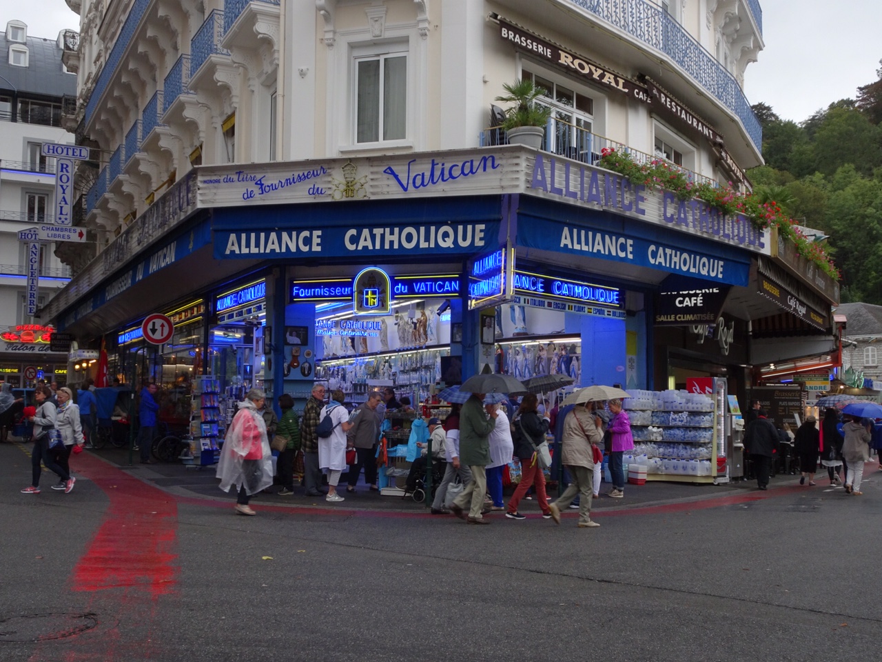 |
| Tat for the discerning pilgrim |
 |
| The last view of the mountains as the rain closes in |
 |
| Looks like we made the right call on the weather! If you look closely, you'll see how high the raindrops were bouncing on the rebound. |
 |
| Our heros and their bikes, now snug in their bags |
Friday, 8 September 2017
DAY 13 - Lourdes to Lourdes via the Aubisque
Lourdes to Lourdes via the Aubisque
54 miles, average 11.9 mph, 1742 m climbed, 3507 kcal used
Weather sunny and warm, windier later on.
Sadly, today was our last proper day of cycling. The original plan was to go out on Saturday too, perhaps to do the Tourmalet, or at least part of it. But the forecast for tomorrow is for very heavy rain and it would not be safe to do the ride in those sorts of conditions.
Almost as a climatic apology for the up-coming deluge, today the weather was very kind; with the early high cloud dispersing quickly. We started with a hotel breakfast; help yourself, all-you-can-eat, always a dangerous thing to offer to a group of cyclists. We noticed that they were running out of food by the time we left...
We headed out of Lourdes in cool but bright conditions, picking up food for the day at a Carrefour Supermarche, before getting onto the Voie Vert, an abandoned railway line converted to cycle route that heads out into the Gave valley. This is a brilliant facility, with a good smooth surface and info boards along the way. It takes you into the heart of the big Pyrenees and breathtaking views in very short time.
Gently climbing, we arrived at Argeles Gazost more quickly than we had anticipated, Roy almost overshooting as he hadn't spotted the rest of us stopping for photos. Here we left the Voie Vert and started the big climb. A couple of km at around 10% and then gradually easing off to a flat section in the middle before the final 8 km at 8-9% up to the first Col, the Soulor. Anticipation is half the battle on climbs this big; you know it is going to last a couple of hours and you have to pace yourself. We all appreciated the lighter bikes, without luggage. Fairly soon, though, Rowan's knees began to give him some trouble, so he and I stopped regularly to try to ease them off, whilst John and Roy carried on at their own pace. Again, with this sort of climb, this is what you have to do; everyone needs to find their own rhythm, so we never deliberately climb the big cold in a group.
Rowan's discomfort unfortunately worsened, particularly on the final 8 km section. Info boards for cyclists at the roadside are placed every km, so these help measure your effort and pace. The stops did allow us to admire the increasingly special views as we got deeper and higher into the mountains. At one point we started hearing the merry jingling of bells, something we had not heard since leaving the Massif Central. As we rounded a corner, we saw why; a whole heard of sheep (with the occasional goat) was coming down the mountain and across the road. We stopped as the tide of animals passed around us.
Further up the road, as we entered the last 2 km, more bells heralded a heard of cows being marshalled up the road. We briefly saw John and Roy passing them on their way to the top (we found out that John had already been up and had come back down to see how the rest of us were getting on!). Then it was our turn to wait behind, before being beckoned through by the herders.
We tentatively passed, always wary when in close proximity to such big animals, especially as a couple were a bit frisky. Then we were there, at the top of the Soulor (1474 m)! A quick photo stop for Ro at the top then we met up with John and Roy for hot chocolate at one of the summit cafes.
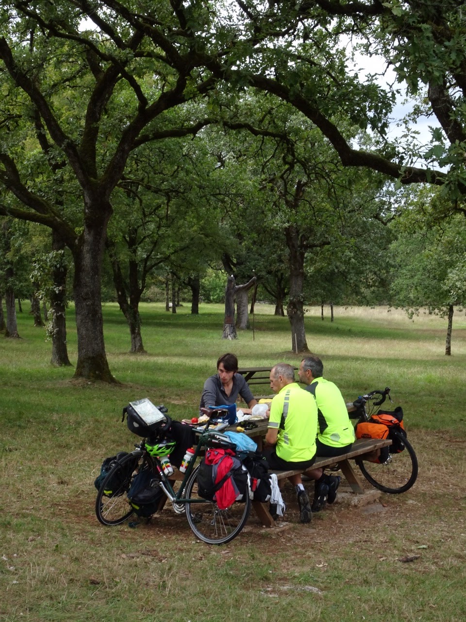
We moved to a bench poised above the valleys, surrounded by the high peaks, for lunch where we watched Griffon Vultures and Kites soaring on the thermals.
Our ultimate objective was the Aubisque, 11 km on from the Soulor. Rowan's knees were not up to this, unfortunately, so it was decided that he would wait at the Soulor whilst the rest carried on. This stretch of road is a highlight of the Pyrenees, part of it traversing an almost vertical face where it has been hacked and tunnelled into the mountainside. The last two times John, Roy and I had been here, it had been in cloud or rain, so we had never seen it at its best. Today could not have been better, with clear blue sky. We dropped away from the Soulor, before climbing, initially gently, finally steeply to the Aubisque. The traverse section was breathtaking, with uninterrupted views down to the valley floor almost at your feet and soaring peaks to the other side.
Spooky tunnel sections chilled the skin. We all reached the Aubisque (1709 m) in good time, conscious that we shouldn't spend too long before returning to Rowan as we had worked out a timetable. So we turned round quickly and headed back.
John particularly enjoyed the route back. I stopped at the plaque commemorating the spot where a Tour de France rider had gone over the edge in 1951 (he survived and wa rescued by his fellow cyclists who used their spare tyres and inner tubes to make an impromptu rope) and followed on.
We arrived to time, promptly had another cafe stop at the Soulor, before the long descent to Lourdes. It took us 1 hr and 5 mins to get from the Soulor to Lourdes.
As I sit and finish off this report on Saturday morning, our decision not to ride has been vindicated as it has been throwing it down all morning. So we will pack our bags with some sadness before heading off on the long journey home this afternoon. In the meantime, we have the flesh-pots of Lourdes to help us forget our tears, as we goggle at the extraordinary souvenirs that are on show for the pilgrims.
Best bits
John - descent from the Aubisque
Roy - getting to the top of the Aubisque
Jeremy - seeing Rowan get to the Soulor despite really sore knees
Rowan - listening to his audiobook in the grand theatre of mountains at the Soulor, whilst waiting for the rest of the team to return from the Aubisque.
54 miles, average 11.9 mph, 1742 m climbed, 3507 kcal used
Weather sunny and warm, windier later on.
Sadly, today was our last proper day of cycling. The original plan was to go out on Saturday too, perhaps to do the Tourmalet, or at least part of it. But the forecast for tomorrow is for very heavy rain and it would not be safe to do the ride in those sorts of conditions.
Almost as a climatic apology for the up-coming deluge, today the weather was very kind; with the early high cloud dispersing quickly. We started with a hotel breakfast; help yourself, all-you-can-eat, always a dangerous thing to offer to a group of cyclists. We noticed that they were running out of food by the time we left...
We headed out of Lourdes in cool but bright conditions, picking up food for the day at a Carrefour Supermarche, before getting onto the Voie Vert, an abandoned railway line converted to cycle route that heads out into the Gave valley. This is a brilliant facility, with a good smooth surface and info boards along the way. It takes you into the heart of the big Pyrenees and breathtaking views in very short time.
 |
Voie Vert out of Lourdes
|
 |
| Mountains looming |
 |
Half way up the Soulor
|
 |
| Sheep stop play ... |
 |
| Then cows... |
 |
| A young man with sore knees, but a good altitude |
 |
Best lunch spot yet
|
 |
| A griffon vulture, (thanks to Blogging Support for the ID) |
 |
And friends
|
 |
Panorama of the Soulor
|
 |
View from the traverse to Aubisque
|
 |
| Pyrenean landscape at the Aubisque |
 |
| Obligatory celebratory mugshot at the top! |
 |
Aubisque panorama
|
 |
The rider that survived
|
 |
Roy on the traverse, going back
|
We arrived to time, promptly had another cafe stop at the Soulor, before the long descent to Lourdes. It took us 1 hr and 5 mins to get from the Soulor to Lourdes.
 |
Goodbye to the mountains
|
 |
| That's Lourdes, pronounced Lurid |
John - descent from the Aubisque
Roy - getting to the top of the Aubisque
Jeremy - seeing Rowan get to the Soulor despite really sore knees
Rowan - listening to his audiobook in the grand theatre of mountains at the Soulor, whilst waiting for the rest of the team to return from the Aubisque.
Thursday, 7 September 2017
DAY 12 - Plaisance to Lourdes
Plaisance to Lourdes
47 miles, 436 m climb, 12.5 mph average (somewhat spoiled by having to walk a km in Lourdes' one way system), 2219 kcal used
Weather: cloudy and cool to begin with, warming up to comfortable with sunny spells.
Today was about reaching Lourdes, our first objective. With the shorter day that we had done a couple of days ago, we had a bit further to go than originally planned, but at less than 50 miles, today was not meant to be tough. Because of this, we were fairly relaxed about packing up the tents, and we eventually rolled out of the camp site and into Plaisance at about 10:15.
It initially looked like our normal luck with boulangerie shops was in play to begin with, as the first one we saw was not only closed, it was out of business. Fortunately we found a second and it was excellent and full of goodies (less so after our visit!).
Then we went further into town to get more food, to find that we were doubly in luck as there was a market on. We got some very nice cheese from one stall, including a wonderous 'bleu' made from both cows and buffalo milk.
Food efficiently gathered, for once, we headed off on quiet country roads, wending in and out of quiet villages, gradually climbing. At about 10 km in, as we came round a corner we could clearly make out the form of the Pyrenees in the distance, a great moment for all of us. The murky weather made them look in destiny to, grey and merged with the clouds, but their presence was indisputable. One of the great pleasures of the day was watching them change and grow through the day.
We lunched on a green in the small village of St Lezer, picnic benches again magicked up as we needed them. There was a display of giant pieces of slate that we didn't understand, but may have been the remnants of some building. A local dog befriended us, and despite our meanness with our food, he stayed with us throughout lunch. In sunnier conditions we set off again, mountains looming ever larger, climb steepening gradually.
We reached the outskirts of Tarbes and had to move into major traffic mode for a while; something we had not had to do for a while. But we navigated through safely and continued to climb on. The air was getting cooler as we climbed higher, with villages subtly changing to tighter clusters of grey buildings. Then we were at the final climb, a brutal but thankfully short stretch at 15% into the village of Bourreac (with a nasty little dab of 17%, just for fun).
We stopped to admire the view of the now very close mountains (and draw breath!) before plunging down a short steep switch back descent into Lourdes. We were there!
Our routing app couldn't cope with the one way system, so we had to walk the bikes a bit before getting to our hotel, but we still made it by 4:30 pm. The hotel is basic but has all we need, and our bike bags, necessary to get us and bikes back, had arrived safely. After unpacking, the bikes, doing washing and listening to the English batting collapse, we wandered out into the madness that is Lourdes to find some food ....
Best bits
John - coming round the corner in Heres and seeing the Pyrenees clearly for the first time.
Rowan - watching the Pyrenees grow gradually through the day
Roy - first sight of the Pyrenees at 10 km in
Jeremy - lunch; great food, company and surroundings
Aubisque tomorrow .........
47 miles, 436 m climb, 12.5 mph average (somewhat spoiled by having to walk a km in Lourdes' one way system), 2219 kcal used
Weather: cloudy and cool to begin with, warming up to comfortable with sunny spells.
Today was about reaching Lourdes, our first objective. With the shorter day that we had done a couple of days ago, we had a bit further to go than originally planned, but at less than 50 miles, today was not meant to be tough. Because of this, we were fairly relaxed about packing up the tents, and we eventually rolled out of the camp site and into Plaisance at about 10:15.
It initially looked like our normal luck with boulangerie shops was in play to begin with, as the first one we saw was not only closed, it was out of business. Fortunately we found a second and it was excellent and full of goodies (less so after our visit!).
Then we went further into town to get more food, to find that we were doubly in luck as there was a market on. We got some very nice cheese from one stall, including a wonderous 'bleu' made from both cows and buffalo milk.
 |
| Market day at Plaisance, very pleasant, as advertised! |
 |
| The "Bench Conjurors" lunch with friend, St Lezer |
 |
| Mountains growing (Um, I think you're just getting closer, Blog Support) |
 |
| Coming to the final climb |
 |
| Cresting the top |
 |
| Lourdes at last! |
Best bits
John - coming round the corner in Heres and seeing the Pyrenees clearly for the first time.
Rowan - watching the Pyrenees grow gradually through the day
Roy - first sight of the Pyrenees at 10 km in
Jeremy - lunch; great food, company and surroundings
Aubisque tomorrow .........
Wednesday, 6 September 2017
DAY 11 - St Pierre de Clairac to Plaisance
St Pierre de Clairac to Plaisance
69 miles, 1611 m climb, 3857 kcals, 11.8 mph average
Weather, sunny, coldish strong wind from the NW
We got caught with a heavy shower in the early morning which lead to a late get away as we tried to dry things off as much as possible. We were away just after 10, aware that we had a long hard day in front of us. The entire route would be one of up and down.
We dropped down off the high ridge that the camping site had been at and crossed the Garonne almost immediately, another of France's big rivers. Our first port of call was Caudecoste in the hope of finding breakfast. We found a boulangerie, but, you guessed, Wednesday was their day for closing. On to the next place and sure enough, closed because of holiday. By the time we got to Astaffort it was 11 am and we were 12 miles into the day, still with no breakfast. So you can imagine our despair when the boulangerie there also proved to be on holiday. Fortunately we found a place a bit like a delicatessen and managed to get a slightly strange mix of food for breakfast and lunch, all of which proved to be delicious.
So it was that we set off just about mid-day, only just having had breakfast and with more than 50 miles to go as the day started to warm up. Our initial route was on a small road that wound its way up and down through countryside scattered with hill top villages, occasional Chateau and with the odd large lorry. We passed the impressive bastide of Lectoure by, glad not to be heading up its steep sides. We continued the up and down theme, now along a ridge top with great views, and stopped for a lunch at Terraube.
Thus fortified we had our only flat run of the day for about 8 miles. Having looked at the route profile for the day, we knew that the last section had 6 more ups and downs, all relatively steep. We counted them down, one by one. Passing through Lupiac, we noticed signs for a fete d'Artagnion that had been held back in August; it would seem that the village is where he is supposed to have come from.
|


 |
| Top of last climb of the day, hooray! |
Finally the last climb, with a brief stop at the top to celebrate, before sweeping down to the small town of Plaisance. Camp site reception had just shut! But we pitched anyway. Bad ground, rough and hard, but we had fun banging pegs in with shoes and throwing acorns at each other!
 |
| Camp ground at Plaisance - with a surface that would make a good car park, and probably usually does! NB. name of place = false advertising! |
One day left to Lourdes...
Favourite bits
Rowan - gorging on all the drinks at the supermarket stop
John - the nice quiet road winding through the countryside just after AstaFfort
Roy - Lunch spot
Jeremy - Lunch spot
Quote of the day: happiness is realising the strip of tarmac going up the hill is not the one we are going on....
Tuesday, 5 September 2017
DAY 10 - Salviac to St Pierre de Clairac
Salviac to St Pierre de Clairac
65 miles, 1153 m climb, 3397 kcal, 11.7 mph average
Weather, warm to hot, some cloud, particularly in the afternoon.
We were delighted to find that our spell of finding boulangeries closed was broken, as the one closest to the camp site was open and full of goodies (empty after we had been through)!
The route today was through limestone country, and across the grain. Consequently we had a series of short climbs and descents with varying lengths of 'going along'. Highlights were dropping into the Lot valley at the delightful town of Duravel. Vineyards abound! The gourde of the river Theze was a pleasant surprise too, marked by limestone pillars and arches at the side of the road.
In the afternoon, after our occult power of magicking up picnic benches was again demonstrated at Tournon d'Agenais, we ended up following the valley of the Petite Seone. Heading into the sun we got increasingly hot, but we passed nowhere with water to top up, so when we reached Puymirol, we were desperate for refreshment. The long climb up into this spectacularly situated Bastide town fortunately proved successful as there was an open bar and epicerie, but only one! We rested under the arches at the centre of the town and enjoyed ice cream and orangina like teenagers (actually one of us is...).
We shopped for food for the night and headed off towards the Camping a la Ferme we had identified the previous night. Initial route as suggested by our bike map app took us to a grassy track, so we had to turnaround and take our own route. No signs at all for the place was a worry, but asking a local got us there. It proved to be a quirky place; they let goats graze around the emplacements, which was a bit nerve wracking. But they have kitchen facilities, so we enjoyed a pleasant evening cooking, eating and watching the farm dogs and cats have fun...
Best moments
Jeremy - Duravel and the Lot
Roy - getting into Puymirol and finding ice cream.
Rowan - getting into Puymirol and finding water!
John - the first taste of orangina in Puymirol
Bit of a theme there...
65 miles, 1153 m climb, 3397 kcal, 11.7 mph average
Weather, warm to hot, some cloud, particularly in the afternoon.
We were delighted to find that our spell of finding boulangeries closed was broken, as the one closest to the camp site was open and full of goodies (empty after we had been through)!
 |
| Opposite of yesterday! And the sign is a nice touch, as if they want to rub it in that this time all the boulangeries were open |
 |
| Gorge de la Theze |
 |
| We heard it through the grape vine in the Lot valley |
 |
| Lunch at Tournon d'Agenais |
 |
| Shade, cold drink and a restorative ice cream at Puymirol. Definitely needed after a long hot day. (You're making this look too much like fun guys!) |
 |
| Viewpoint from Puymirol |
 |
| Misdirected by the routing software ... we decided not to follow this route to the camping a la femme |
 |
| Camping a la Ferme, with hot and cold running... goats... Hmm. |
Jeremy - Duravel and the Lot
Roy - getting into Puymirol and finding ice cream.
Rowan - getting into Puymirol and finding water!
John - the first taste of orangina in Puymirol
Bit of a theme there...
Monday, 4 September 2017
DAY 9 - Pont de Rhodes to Salviac
Pont de Rhodes to Saliva
65 miles, 1126 m of climb, average 13 mph, 3435 kcal used
Weather was mixed cloud and sun, once early morning rain had cleared. Warming up!
We were a bit late up, possibly due to the thick curtains in the rooms. We ended up leaving not far off 10 am just as a rain shower had finished its work, so it was on wet roads that we left the hotel, immediately tackling a 100 m climb to our highest point of the day. Then it was a bit of up and down before coming into the first major settlement of the day, Sousceyrac, where we hoped to pick up the food for the day. But guess what, Monday is local day for the boulangerie and patisserie to be shut! Our tour seems to be following the shut day around!
 |
| This picture represents all of the closed boulangeries and patisseries that we came across this morning. |
Our route was briefly busy, along the side of the river Bave. We started to see limestone cliffs to the south, and sure enough we were climbing up towards a picturesque village perched at the top of one - Loubressac. The climb was steady and we were rewarded with great views of Chateau de Castelnau on the way up. The village itself was very beautiful for itself as well as its situation, something that was notable for many of the villages in the area.
 |
| The immaculate small village of Loubressac, perched on top of our second main climb of the day, now in limestone country |
 |
| The village itself |
As we left the village we came across a memorial that had been erected to commemorate the support of the resistance by US forces during the Second World War. We carried on across the countryside, passing through small villages, eventually stopping for lunch just short of Rocamadour. We noted that it was a very touristy area, one of the attractions being the chevre cheese, as well as foie gras (the goose torturers favourite pate). We lunched contentedly at a picnic site with a rather nicely done carving that had used an in situ tree - without any foie gras.
 |
| The WW2 resistance memorial above the village |
 |
| Nice lunch spot just before Rocamadour. |
 |
| Wood sculpture at lunch spot. Wonder why he's so worried? |
 |
| Spectacular Rocamadour |
 |
| The Rocamadour gorge which we cycled down into and then back out of. |
 |
| Hot chocolate & coffee stop in manicured Cales - note bikes in neat formation |
 |
| Our rather nice camp site at Salviac - the grass contains mint so you get a nice aroma as you walk around |
Best bits
Rowan - Rocamadour
Roy - the Rocamadour Gorge
John - arriving in Gourdon to find the supermarket open
Jeremy - arriving at the campsite, not just 'cos it was the end of the day, but because it was such a nice place.
Random thought of the day
Regular readers of the blog may have noticed that this feature has been missing for a while. That's not because we don't have them, it's more because at this stage of the ride, we can't remember them at the end of the day!
Subscribe to:
Posts (Atom)
-
 After a great evening out with the Rushton family and guests for Rowan's 18th, we were up at 6 am to pack and get down to the Eurostar d...
 -
 Day 1 report, Paris to L'Ile du Saussay Total distance 34 miles, average 10.3 mph Weather - 30 degrees hot, sunny You'll rememb...
 -
 Day 2 write up L'Ile de Saussey to Chateauneuf sur Loire 63.2 miles, 553 m of climb, 13.1 mph average speed, 2942 kcal used Weather h...